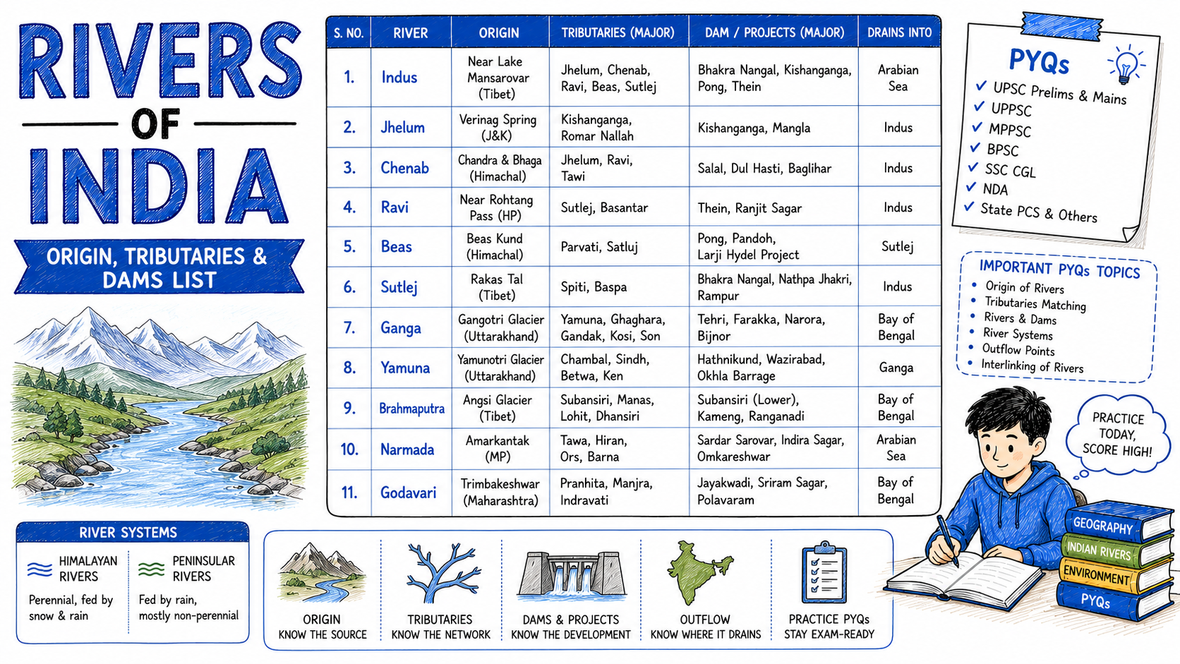
Rivers is one of the biggest scoring topics in Geography. Every exam asks 1 to 2 questions, and the answers never change. But students often try to learn every river in India and end up remembering none. This post covers only what actually gets asked — origin, tributaries, dams and cities — in simple tables, with 15 real questions from past papers.
Key Points (Quick Revision)
- Ganga — longest river flowing entirely within India
- Indus and Brahmaputra both originate near Lake Mansarovar in Tibet
- Narmada and Tapti are the main west-flowing rivers, and both flow through rift valleys
- Godavari is the longest river of South India, called Dakshin Ganga
- Peninsular rivers are rain-fed; Himalayan rivers are fed by snow, so they flow all year
1. Himalayan rivers — origin and key facts
These rivers begin in the Himalayas and are fed by melting snow. That is why they never dry up, even in summer.
| River | Origin | Key fact |
|---|---|---|
| Ganga | Gangotri Glacier, Uttarakhand | Longest river entirely within India; called Bhagirathi before Devprayag |
| Yamuna | Yamunotri Glacier, Uttarakhand | Longest tributary of the Ganga; meets it at Prayagraj |
| Indus | Near Lake Mansarovar, Tibet | Called Sindhu; flows mainly through Pakistan |
| Brahmaputra | Near Lake Mansarovar, Tibet | Called Tsangpo in Tibet, Siang in Arunachal, Jamuna in Bangladesh |
| Sutlej | Rakshastal Lake, Tibet | Longest of the five Punjab rivers; Bhakra Dam is on it |
| Beas | Beas Kund, Himachal Pradesh | Does not cross into Pakistan |
| Ravi | Bara Bhangal, Himachal Pradesh | Smallest of the five Punjab rivers |
| Chenab | Bara Lacha Pass, Himachal Pradesh | Largest of the five Punjab rivers by water volume |
| Jhelum | Verinag, Jammu and Kashmir | Srinagar is on its bank |
Remember one thing clearly. Indus and Brahmaputra both start near Lake Mansarovar in Tibet, but they flow in opposite directions — Indus to the west, Brahmaputra to the east. This pair is asked very often.
2. Peninsular rivers
These begin in the Western Ghats or central highlands and depend on rain, so their water level drops sharply in summer.
| River | Origin | Flows into |
|---|---|---|
| Godavari | Trimbakeshwar, Maharashtra | Bay of Bengal — longest in South India |
| Krishna | Mahabaleshwar, Maharashtra | Bay of Bengal |
| Kaveri | Talakaveri, Karnataka | Bay of Bengal — called Ganga of the South |
| Mahanadi | Chhattisgarh | Bay of Bengal — Hirakud Dam is on it |
| Narmada | Amarkantak, Madhya Pradesh | Arabian Sea — flows west through a rift valley |
| Tapti (Tapi) | Betul, Madhya Pradesh | Arabian Sea — flows west |
| Chambal | Janapav Hills, Madhya Pradesh | Joins the Yamuna; famous for ravines |
| Sabarmati | Aravalli Range, Rajasthan | Arabian Sea — Ahmedabad is on its bank |
📌 Exam Focus
- Asked most often: which rivers flow west (Narmada, Tapti, Mahi) — everything else flows east
- Common trap: Godavari is longest in South India, but Ganga is longest in all of India
- Sure-shot: Narmada originates at Amarkantak, Godavari at Trimbakeshwar, Kaveri at Talakaveri
3. Important dams and their rivers
Dam questions are almost always paired with the river. Learn them together, never separately.
| Dam | River | State |
|---|---|---|
| Bhakra Nangal | Sutlej | Himachal Pradesh / Punjab |
| Hirakud | Mahanadi | Odisha — longest dam in India |
| Sardar Sarovar | Narmada | Gujarat |
| Tehri | Bhagirathi | Uttarakhand — tallest dam in India |
| Nagarjuna Sagar | Krishna | Telangana / Andhra Pradesh |
| Mettur | Kaveri | Tamil Nadu |
| Idukki | Periyar | Kerala |
| Indira Sagar | Narmada | Madhya Pradesh |
| Rihand | Rihand | Uttar Pradesh |
| Farakka Barrage | Ganga | West Bengal |
4. Cities on river banks
| City | River |
|---|---|
| Delhi | Yamuna |
| Agra, Mathura | Yamuna |
| Varanasi, Kanpur, Patna | Ganga |
| Prayagraj | Ganga and Yamuna meet here |
| Kolkata | Hooghly |
| Ahmedabad | Sabarmati |
| Surat | Tapti |
| Nashik | Godavari |
| Srinagar | Jhelum |
| Guwahati | Brahmaputra |
| Jabalpur | Narmada |
| Lucknow | Gomti |
5. How it is asked in exams — 15 PYQs
- The Ganga originates from which glacier? — Gangotri Glacier (SSC CGL 2023)
- Which river is known as Dakshin Ganga? — Godavari (SSC CHSL 2023)
- The Narmada river originates from? — Amarkantak (SSC MTS 2023)
- Bhakra Nangal Dam is built on which river? — Sutlej (RRB NTPC 2024)
- Which city is situated on the banks of the Sabarmati? — Ahmedabad (SSC CGL 2022)
- Hirakud Dam is built on which river? — Mahanadi (SSC GD 2024)
- Which two rivers meet at Prayagraj? — Ganga and Yamuna (SSC CHSL 2024)
- The Brahmaputra is known by which name in Tibet? — Tsangpo (RRB Group D 2024)
- Which is the longest tributary of the Ganga? — Yamuna (SSC CPO 2023)
- Tehri Dam is built on which river? — Bhagirathi (SSC MTS 2024)
- Which river flows through a rift valley into the Arabian Sea? — Narmada (SSC CGL 2024)
- The Kaveri river originates from? — Talakaveri, Karnataka (RRB NTPC 2025)
- Srinagar is situated on the banks of which river? — Jhelum (SSC CHSL 2022)
- Which is the largest of the five Punjab rivers? — Chenab (SSC GD 2023)
- Sardar Sarovar Dam is built on which river? — Narmada (SSC CGL 2023)
6. Quick Revision
⚡ At a Glance
- West-flowing: Narmada, Tapti, Mahi, Sabarmati, Periyar — everything else flows east
- From Tibet: Indus, Brahmaputra, Sutlej
- Longest: Ganga (in India) · Godavari (in South India)
- Longest dam: Hirakud · Tallest dam: Tehri
- Amarkantak is where both the Narmada and the Son begin
Frequently Asked Questions
Which is the longest river in India?
The Ganga is the longest river flowing entirely within India, at about 2,525 kilometres. The Indus is longer overall but most of its course lies in Pakistan. In South India, the Godavari is the longest, which is why it is called Dakshin Ganga.
Which rivers of India flow towards the west?
Narmada, Tapti, Mahi, Sabarmati and Periyar flow west into the Arabian Sea. All other major rivers flow east into the Bay of Bengal. Narmada and Tapti are special because they flow through rift valleys, which is why they form estuaries instead of deltas.
Where do the Indus and Brahmaputra originate?
Both originate near Lake Mansarovar in Tibet, but they flow in opposite directions. The Indus flows west and mainly through Pakistan, while the Brahmaputra flows east through Tibet and Arunachal Pradesh before turning south into Assam and Bangladesh.
What is the difference between Himalayan and Peninsular rivers?
Himalayan rivers such as the Ganga, Yamuna and Brahmaputra are fed by melting snow, so they carry water throughout the year. Peninsular rivers such as the Godavari, Krishna and Kaveri depend on rainfall, so their flow drops sharply in the dry season.
How many questions come from rivers in exams?
Usually one to two questions per paper in SSC and Railway exams. They ask the origin of a river, which dam is built on it, or which city lies on its bank. Since these facts never change, this is one of the most reliable scoring areas in Geography.
For more Geography topics explained simply, see our National Parks of India post and the Geography section. Preparing for a specific exam? Start with the SSC CGL guide or join the 100 Hour GS Course.